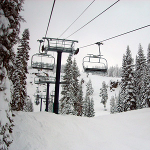
Skiers and riders will have plenty of fresh power for the President’s Day weekend. Resorts are expecting 2-5 feet of new snow to arrive by Friday night. The snow is expected to taper off on Saturday. Sunday and Monday should be dry and partly sunny.
Heavy traffic and chain requirements on and off are expected throughout the weekend. For the latest road reports and live weather cams of Kingvale and Truckee click here
Weather update courtesy of Sugarbowl:
After light snow for the past 24 hours, conditions become favorable for heavy snow beginning this afternoon as a strong cold front approaches. A few to several inches may accumulate before sunset, depending on the storm’s timing, with the heaviest accumulations occurring overnight. Around 2 additional feet of accumulations are expected by dawn Wednesday. Temperatures today in the 20s to low 30s, then falling in the afternoon. Southwest winds to 30 mph with higher gusts, to 70 mph with higher gusts, strongest in the afternoon.
Colder temperatures and more snow on Wednesday with the passing of the cold front. Accumulations during the day in the 8-18 inch range with additional light accumulations after dark. Temperatures in the teens. West to southwest winds to 20 mph, to 60 mph on the ridges with higher gusts.
A cutoff area of low pressure develops offshore on Thursday to make forecasting difficult. Some models are sending the system to our south, but enough energy is expected in our area for moderate accumulations. Other models may have a more northerly track to bring even better accumulations. Snow shower chances in the morning with snow rates likely to increase later in the day and overnight. An additional 6-12 inches are expected by Friday morning depending on the track of the low. Lows in the upper single digits to low teens, highs in the teens. Winds not as strong as our current system.
Snow chances continue on Friday with light accumulations possible, of course, depending on the position of the low at that time. Lows in the upper single digits to low teens, highs in the teens to near 20.
One last shot of snow on Saturday as the low pressure center exits. Little or no accumulations expected. Lows near 10, highs in the teens to mid 20s.
At this time, a weak ridge of high pressure is expected to bring dry conditions on Sunday. Partly sunny with lows in the teens, highs in the 20s.
The high pressure ridge begins to exit on Monday, but holding on just long enough to bring another dry day. Lows in the teens to low 20s, highs in the 20s to low 30s.
A low pressure tough developing offshore will bring more snow chances beginning late Monday or Tuesday.